RobbHaas Family Pages |
Land Patent Enos Hiatt ID3931 |
Home | Sources | Images |
Land Patent Information |
Legal Land Description: North East quarter of the North East quarter of section twenty seven in township nineteen North of Range four East |
Approximate location of the land: 40° 04'18.71" N 86°03'13.27" W |
Noblesville Township, Hamilton County, Indiana |
Land Patent Issued: 16 Apr 1835 |
Recorded, Hamilton County, Indiana: 23 Nov 1841 |
Transcription | Image (Click for larger View) (To Magnify larger image - use CTRL + ) |
|
Land Patent Information from BLM for Land Patent - S1, |
Ph8386-001.jpg (Accessed 4 May 2007)
|
|
Legal Land Description from BLM - S2,
|
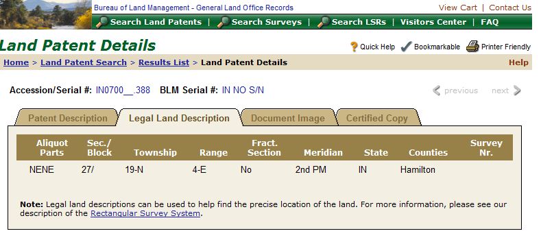
Ph8386-005.jpg (Accessed 12 Sept 2010) |
|
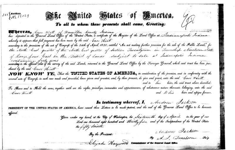
Image of Original Land Patent - BLM - S3,
The original Land Patent was dated 16 Apr 1835 |
388 {Certificate No. 18029 The
United States of America Whereas
Enos Hiatt of Hamilton County Indiana has deposited in the General
Land Office of the United In testimony
whereof, I, Andrew Jackson Given under my hand at the City of Washington, the sixteenth day of April in the year of our Lord one thousand Eight hundred and thirty five and of the Independence of the United States the fifty ninth. By the President Andrew Jackson By A L Donelson, Sec’y Elijah Hayward Commissioner of the General Land Office.
|
Ph8386-003.jpg |
Handwritten copy of Land Patent by Hamilton County Recorder - S4, This copy is dated 23 Nov 1841 |
Deed Record “H” Page 395 Certificate No 18029
The United States of America
Whereas Enos Hiatt
of Hamilton County Indiana has deposited in the
Given under my hand at the City of
Washington, this By the President Andrew Jackson
The above patent was presented to me
for Record Nov 23 1841 and A B Cole [signature]
|
Ph8386-002.jpg |
Current day image of Section 27 - S5, | -- The violet square
indicates Section 27 on the map - The property was located in the NE
corner of the township -- The water shown at the top is present-day Morse Reservoir -- The road is Highway 38 between Noblesville and Sheridan |
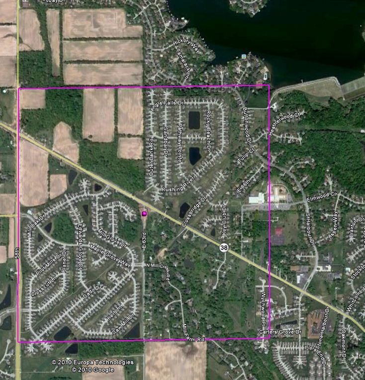
Ph8386-006.jpg |
1880 Map of a portion of Noblesville Township - [S6, between pages 82 & 83] - | -- Section 27 is to the
northwest of Noblesville on the map -- The creek "Cicero Creek" shown on this map is today a part of the Morse Reservoir from the northeast corner of Section 27 - The reservoir follows the creek to the northeast |
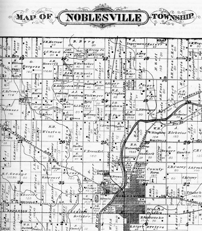
Ph8386-007.jpg |
1880 Map of Section 27 - [S6, between pages 82 & 83] - |
-- L Hiatt is shown owner
of 36 acres in the northeast corner of Section 27 -- Notice the junction of two creeks just to the north of the L Hiatt land - This is Cicero Creek and today a part of Morse Reservoir -- The road cutting through the section is the Noblesville & Lafayette G.R. [Gravel Road] - Today it is Highway 38 |
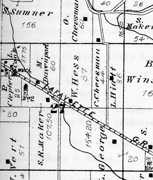
Ph8386-008.jpg |
Sources | ||
Source Citation |
Image |
|
S1 | Web Page. Bureau of Land
Management - "Land Patent Details/Patent Description" - "Enos
Hiatt" Document Number 18029. Issue Date: 16 Apr 1835,
Indianapolis, Indiana, accessed 12 Sept 2010. Acc000918 URL: http://www.glorecords.blm.gov/PatentSearch/Detail.asp?PatentDocClassCode=STA&Accession=IN0700__.388&Index=1&QryID=39172.93&DetailTab=1 |
|
S2 | Web Page. Bureau of Land
Management - "Land Patent Details/Legal Land Description" -
"Accession/Serial #: IN0700__.388 BLM Serial #: IN No
S/N", accessed 12 Sept 2010 - Acc000918 URL: http://www.glorecords.blm.gov/PatentSearch/Detail.asp?PatentDocClassCode=STA&Accession=IN0700__.388&Index=1&QryID=39172.93&DetailTab=2 |
|
S3 | Web Page. Bureau of Land
Management - "Land Patent Details/Document Image", accessed 12 Sept
2010 - Acc000918 URL: http://www.glorecords.blm.gov/PatentSearch/Detail.asp?PatentDocClassCode=STA&Accession=IN0700__.388&Index=1&QryID=39172.93&DetailTab=3 |
|
S4 | Image of a photocopy of a photocopy of a handwritten copy of the Land Patent. Created by A B Cole, Recorder, Hamilton County, Indiana. Dated 23 Nov 1841. Original Data: Hamilton County Recorders Office, Vol 36, Page 388. (Deed Record "H" page 393) Repository: Hamilton East Public Library/ Family History Vertical Files/ in Robbins, Tomlinson and Hiatt folders. Acc000918/ Ph8386-002.jpg |
Ph8386-002.jpg |
S5 | Google Earth - Earth Point - Tools for Google Earth - http://www.earthpoint.us/Townships.aspx (Plotted the Township and Section on Google Earth using the BLM Legal Land Description) |
|
S6 | Helm, T B. History of
Hamilton County, Indiana, Reprint . Chicago, Evansville, IN:
Kingman Brothers, Unigraphic, 1880, 1976. Bk1604 Read Online: http://www.archive.org/stream/historyofhamilto00helm#page/n7/mode/2up |
|
S7 | ||
S8 | ||
S9 | ||
S10 | ||
S11 | ||
S12 | ||
S13 | ||
S14 | ||
S15 | ||
S16 | ||
S17 | ||
S18 | ||
S19 | ||
S20 | ||
S21 | ||
S22 | ||
S23 | ||
S24 | ||
S25 |
Email Me for More Information - Page updated: -