|
RobbHaas Family Pages |
Richwoods PO Delaware County, Indiana |
|
Township:
Salem ?? Monroe ?? |
| Location:
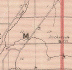
Coordinates: Two different locations found: (About 1.8 miles between them) (Progress was established later in the middle of these two locations) 1. The Intersection of Muncie Middletown Pike (St. Rd. 67) and Range Line Pike (CR300W) - (Coordinates: 40.1323 -85.4432) [S7, p 17] - [S14] - - The 1887 Atlas shows the Richwood P.O. just south of the Toll Gate at this intersection. - It is situated in the eastern extremity of the township, [Salem] at the junction of the Range Line with the Middletown and Muncie Turnpike." [S1, page 286] (Richwood Knights of Honor, Lodge No. 490) 2. Corner of CR300W and CR600S (Coordinates: 40.1057 -85.4426) Comparison of [S3] and [S4] - [S14] - 1870 Map: "Richwoods P.O." [S5] - (No indication of a precise location, but near the border of Salem & Monroe Townships, near the road west from Cowan - Richwoods PO. and Sockum are shown very close together on this map - Sockum is shown north of Richwoods PO) (1870 map) 1876 Map: "Richwoods P.O." [S4] - NW corner of CR300W and CR600S - Coordinates: 40.1057 -85.4426 (Comparison of [S3] and [S4] ) (Border of Salem and Monroe Townships on the Salem Side) |
| Other Names:
Richwood: Richwoods: Rich Woods: [S13, p 135] Richwoods PO: [S4] - [S5] - |
| Date Platted: |
| Maps: 1870: "Richwoods P.O." [S5] - (No indication of a precise location, but near the border of Salem & Monroe Townships, near the road west from Cowan - Richwoods PO. and Sockum are shown very close together on this map - Sockum is shown north of Richwoods PO) 1876: "Richwoods P.O." [S4] - Coordinates: 40.1057 -85.4426 (Comparison of [S3] and [S4] ) (Border of Salem and Monroe Townships on the Salem Side) |
| Post Office Data:
Post Office Established: 19 Aug 1843 [S8,
p 1016] - |
| Postmasters:
[S8, p 1016] John Tomlinson -- 19 Aug 1843 |
| Railroad: - March 1898: "Midland (C. & S.E.) R.R. resumes building from Anderson to Muncie; Grade Completed to within four miles of Muncie, about Richwoods." [S6, p 189] - |
| Churches: Richwood Evangelical Lutheran Church - - Organized 1865, at Schoolhouse No. 7 (SE corner of CR500W and CR500S - Coordinates: 40.12042 -85.49956) - New building dedicated 20 June 1869, brick, cost $3,000 - [S1, p 286] - "Richwood Ch" shown on 1887 Atlas located at Cross Roads P.O. [S7, p 17] - |
| Societies:
Richwood Lodge No. 490, Knights of Honor - - Organized 28 Feb 1877. S1, page 286 - "Charter Members: D.R. Armitage, Samuel Drum, W.H. Neff, C.C. Heath, T.W. Tuttle, W.F. Andes, S.C. Moffett, H.H. Reed, George W. Lykens, A.M. Heath, S.F. Heaton, William Miller, Isaac Lake, Samuel Clevenger, B.F. Childs, G.W. Bates and J.R. McLain." [S1, page 286] - "The first meetings were held in an up-stairs room in the residence of J.W. McKimmey, near Tabor Post office. The present lodge-room is a well furnished second story room, 20 x 40 feet, with two ante-rooms. It is situated in the eastern extremity of the township, [Salem] at the junction of the Range Line with the Middletown and Muncie Turnpike." [S1, page 286] |
| "July 12 - Death of Terrell Summers in Salem township, aged 69, who came to Richwood's settlement in 1832." [S6, p 170] |
| [Richwood Post Office] "is a small hamlet on the west part of the township [Monroe]. There is a store at this point, kept by David Lykins; Elias Good is the postmaster and toll-gate keeper, and David Lykins, Jr., has the blacksmith shop." [S1, p 265] |
| "The Country store, built and kept by 'Uncle davy' Lykins, had a long room upstairs which was used as a meeting place by a lodge. The building burned in 1909." [S2, 8 March 1991] |
| "Originally the face of the country was covered by heavy forests of the variety of timber common to this section of the country, but the immense growth of black walnut timber in section 21, the west half of section 22, the east half of section 20, and the south half of section 16 gave to this neighborhood the name of the 'Rich Woods,' by which name it has been known for many years." [S13, p 135] |
| "Section 15, in Salem Township, is in the south central part of the township, and that our readers may th more readily understand its location, we will state that Cross Roads, Pos Office and Village, is situated in the southwest corner of the section. As this section borders on the Richwoods neighborhood, the land has been held at a high value, ..." [S13, p 146] |
| "Richwood post office on the west side of the township belongs in the list of those little communities that existed chiefly because of the post office and have ceased to be since the rural routed superseded the post office." [S6, p 102] |
| The first sketch shows a country store with a rail-fence
nearby. A small building is labeled TOLL GATE and shows a
barrier across the road. The location of the toll gate was
where Progress Road meets Ind. 67. Ruth Lafferty said she
could remember when a toll was charged to enter the road she
knew as Middletown Pike. The County Store, built and kept by "Uncle Davy" Lykins, had a long room upstairs which was used as a meeting place by a lodge. The building burned in 1909. A Sketch called "The Country Store Gang" shows 10 loafers at the store owned by "Uncle Davy" Lykins. A man, known as Coon Dog Pete, sits on the counter, gesturing and telling tall-tales to his avid listeners. Some have pipes in theri mouths, other must chew tobacco, as several boxes sit on the floor, thought to be filled with sawdust, and serving as cuspidors. Bolts of cloth line the shelves, while pans, buckets and kettles sit on the top shelf. Source: "Seen and Heard in Our Neighborhood" by Ruth Hillman. The Muncie Star (Muncie, Delaware County, Indiana, 8 March 1991. |
| Sources: [S2, 27 Mar 1972] - [S7, page 17, 23] - [S9, p 133] - [S10] - [S11, p 229] - [S12] - |
| Sources | ||||
|
Source Citation |
Image |
|||
| S1 | Helm, T.B. History of Delaware County, Indiana. Chicago: Kingman Brothers, 1881, reprint ed., Evansville, Indiana: Unigraphic, Inc., 1976, Bk1595. | |||
| S2 | "Our Neighborhood". Muncie, Indiana: The Muncie Star. | |||
| S3 | Google Maps: Location #1: Search: 40.1323 -85.4432 Location #2: Search: 40.1057 -85.4426 |
|||
| S4 | Map: Delaware
County, Indiana, 1876. (Published by Baskin, Forster & Co.
Lakeside Building Chicago, 1876. Engraved & Printed by Chas.
Shober & Co. Props. Of Chicago Lithographing Co.) David Rumsey
Map Collection.
http://www.davidrumsey.com/luna/servlet/detail/RUMSEY~8~1~23110~790090:Map-of-Delaware-County---Published-#
Accessed, 27 Feb 2012. Acc002078/Ph9386-001 to 041.jpg Detail: Richwoods PO, Salem Township |
Ph9386-030.jpg |
||
| S5 | Map: Asher, Adams &
Higgins. New Topographical Atlas and Gazetteer of Indiana,
multiple counties including Delaware, Blackford, Madison, and
Hamilton and others. Indianapolis: Higgins & Ryan, 1870, pages
19, 20. David Rumsey Map Collection.
http://www.davidrumsey.com/luna/servlet/detail/RUMSEY~8~1~33585~1171285:New-topographical-atlas-and-gazette?sort=Pub_List_No_InitialSort%2CPub_Date%2CPub_List_No%2CSeries_No#
Accessed 28 Feb 2012. Acc002079/Ph9387.jpg Map Detail: Salem Township, Delaware County |
|||
| S6 | Kemper, G.W.H., M.D., ed. A Twentieth Century History of Delaware County Indiana, 1908; reprint ed., Evansville, Indiana: Whippoorwill Publications, 1984. Bk3012. |
Vol. 1 Vol. 2 |
||
| S7 | An Atlas of Delaware County, Indiana. Philadelphia: Griffing, Gordon & Co, 1887, reprint ed., Knightstown, Indiana: Mayhill Publications, 1971, Bk1849. | |||
| S8 |
Baker, J. David. The
Postal History of Indiana, Vol. 2.
Louisville, Ky: Leonard H. Hartman, 1976, Bk3010. Repositories: Bracken Library, Ball State University and Anderson Public Library |
|||
| S9 |
Baker, J. David. The
Postal History of Indiana, Microfiche.
Louisville, Ky: Leonard H. Hartman, 1976, Bk3010. Repositories: Bracken Library, Ball State University and Anderson Public Library |
|||
| S10 | Map of Delaware County, Indiana. Compiled by H. Lester Janney. Revised by Ward M. Harlan, 1965. | |||
| S11 | United States Official Postal Guide. Boston: H.O. Houghton and Company, April 1875, Bk1548. | |||
| S12 | Greene, Richard A. Muncie and Delaware County: An Historical Sketch. Muncie, Indiana: Delaware County Historical Society, 1965, Bk1872. | |||
| S13 | Ellis, John S. Our County: [Delaware County, Indiana] Its History and Early Settlement by Townships. (1890). Evansville, Indiana: Whipporwill Publications, Reproduction, 1987. Bk2082. | Archive.org | ||
| S14 | Google Custom Map "Salem Township, Delaware County, Indiana" | Link | ||
| S15 | Flook, Chris. Lost Towns of Delaware
County, Indiana. Charleston, South Carolina: The History Press,
2019. Bk4212 http://lostdelawarecounty.chrisflook.org/ |
|||
| S16 | ||||
| S17 | ||||
| S18 | ||||
| S19 | ||||
| S20 | ||||
| S21 | ||||
| S22 | ||||
| S23 | ||||
| S24 | ||||
| S25 | ||||