|
RobbHaas Family Pages |
North of Eaton Farm Union Township, Delaware County, Indiana 1948-1953 |
| Home | Residences Index | Sources | Images |
| Purchase Date:
Walter & Norma Robbins: 8 June 1948 Purchased From: Carl O. Tobias and Sylva L. Tobias - [S16] [S17] Sold Date: 4 March 1953 [S7] [S9] Sold to: Elmer & Ruby Noel on Contract ($11,000.00) Sold Date: 14 Jan 1955: Sold to: The Noel Couple sold the farm to Leo and Rachel Bettegnies, [ S7] [S9] - Noel's paid off their contract to Walter & Norma Robbins ($7859.00) [S7] |
|
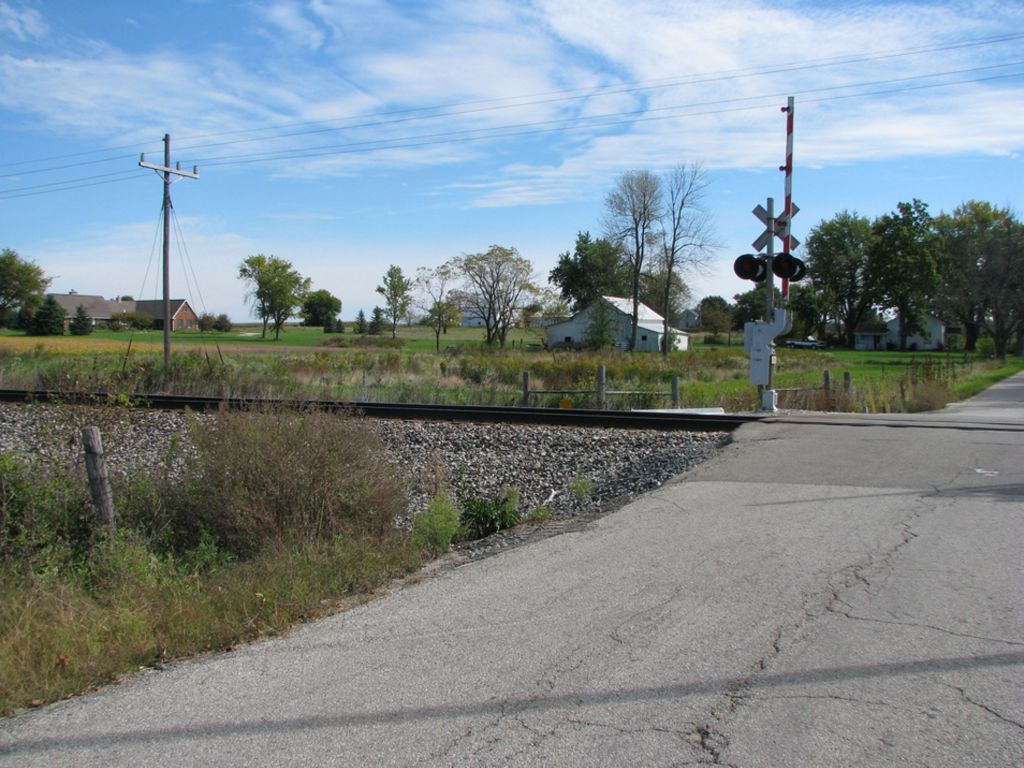
Location
- - Union Township, Delaware County, Indiana [S16] [S18] [S19] - Section 11, Union Township [S16] - North side of CR 1200N just east of the Norfolk and Western railroad tracks and west of CR 200E - This farm was located approximately 1.75 miles north of Eaton - One mile north of Eaton [S16] - Coordinates: 40°21'51.70”N 85°21'24.31”W - (Google Map Coordinates: 40.364553206190266, -85.35677962208977 ) - Google Custom Map (Also Shows location of Poor School) - Addresses: - Address when the Robbins Family lived here: R R 1, Eaton, Indiana [S18] [S19] [S20] - Current address (2021): 2770 E CR1200N, Eaton, IN 47338 - Maps: - 1874 Plat Map - Union Township, Delaware County, Indiana - S11, - 1952 Plat Map - Bk1869 - Ph8576.jpg S5, - House Floor Plan - Doc0609.pdf |
| Property Size:
25.89 acres [S16] [S17]
Property Description: [S17] All that part off the South West quarter (SW1/4) of the South East quarter (SE1/4) of Section eleven (11), Township twenty- two (22) North, Range ten (10) East, that lies East of the Fort Wayne, Cincinnati and Louisville Railway (now the Nickel Plate Railway), and bounded and described as follows:- Commencing at the Southeast corner of said South West quarter (SW1/4) of said South East quarter (SE1/4) of Section eleven (11), and running thence North eight (80) rods; thence West fifty-one and seventy-eight hundredths (51.78) rods, more or less to the East line of said Nickel Plate Railway right of way; Thence South on and along said East line of said Nickel Plate right of way, eighty (80) rods, more or less, to the south section line; thence East on and along said South section line, fifty-one and seventy-eight hundredths (51.78) rods to the place of beginning and containing twenty-five and eighty-nine hundredths (25.89 acres, more or less. |
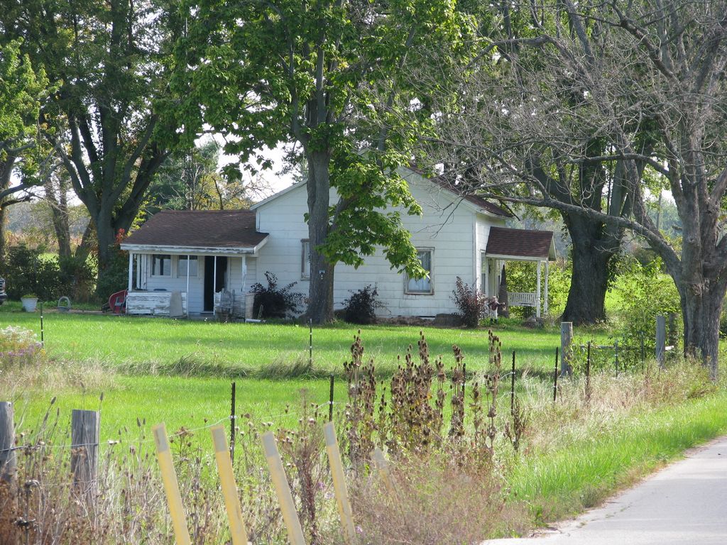
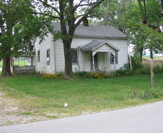
| This farm consisted of 26 acres. There was a small house, a barn and a 2-hole outhouse. I cannot remember the layout of the house. Dad stated that he installed a bathroom in the house but I don't remember any of that. |
| I remember
that I messed with the telephone at this house and the repairman had
to come out to repair it - I had unscrewed the mouthpiece and turned
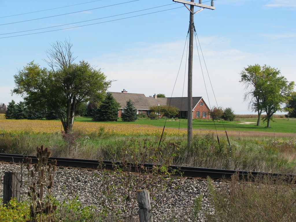
the disk inside upside down or something. I remember that we had an outhouse and it was a 2-holer - I also recall there was an apple orchard to the east of the house and the neighbors to the east were named Rector and they had 2 older boys, one of which took me to my first grade class on my first day of school. A Railroad track ran north and south to the west of the house. A single train would go north in the morning and come back south in the afternoon every day. The cars were pulled by a single coal-fired steam engine. I liked to watch the train go by every day. On several occasions hobos would jump off the train near our house because it began slowing down for Eaton at that point. They would oftentimes come to the house to see if they could do some work for some food. Usually Mom would just give them something to eat and not require them to do anything for us. They were polite and thankful for whatever they received and went on their way. We got out first television at his house. I can remember how great I thought it was. It was black and white and the picture was very fuzzy most of the time - Dad had to constantly go outside to adjust the antenna which was on a pole outside the house - by rotating the antenna the picture would get better or worse depending on the time of day, weather, etc. My sister was born while we were living at this house I also remember that my dog Duke was born here. We had some cows in the barn and Dad had made stalls and a trench for the cows to use. Dad had an old Ford Truck and one day after he had left for work I was playing in it and somehow got it started and ran it into the foundation of the barn - I don't know if I caused any damage or not. I recall that on the north end of the property there was a trash pile that was in a gully or something. |
| Postcards sent or received while living on this farm: - Link - (See: Index/North of Eaton Farm) |
| Norma Haas Robbins, 1992: "we soon decided we wanted more acreage - so we sold it [Centennial House] and bought 25 acres in Eaton. The house was an old schoolhouse not too bad - but the yard looks like a weed patch. We cleaned it up - remodeled the house & barn. I was slowly learning to be a farm wife. I had to milk the cows - no running water in house - we had a pump house right by the house - had to get our water there - now, you realize that meant - No Bathroom once again. So now here we go again, remodeling, changing the kitchen, adding a bathroom. It was nice except for the ceilings. They were 9 feet high. I stood on the top of an 8 foot ladder painting the bedroom ceiling - I could barely reach the ceiling; but I got it done" S2, |
| Interview, Walter Robbins, Sr., ID0005, 22 Sept 2005, page 17, 18: Walter sided the barn as one of the first things after they purchased the farm. He also put in a new bathroom in the house. He built the shed on the north side of the barn and constructed new stalls for cows, probably about 6 stalls with stanchions, and poured a concrete floor with the groove for the drainage behind the cows. He bought a cement mixer because of this project. Probably had 3 - 5 cows and he planted hay and corn in the field directly behind the house and barn where the new house and pond sits today. The field next to the railroad was used as pasture. There was an old wide-wheeled tractor on the farm when purchased. It was a John Deere with steel wheels with studs as I remember. Dad later purchased a Farmall F-20 tractor. He also had an old truck at this farm that he really liked - I remember one time while dad was at work at Chevrolet I got into the truck and was playing around and somehow got it started and ran it into the barn. Doc0551.pdf |
| From My Baby Book: Under "Birthdays" in the center of the book it states that I was living at R R 1, Eaton, Delaware County, Indiana on my fifth and sixth birthdays - the farm north of Eaton was described as: "1 mile north of Eaton. East of State Road 3 about 2 mile. 25 acres" S4, |
| Poor School: We were told when living at this property that the house was originally the Poor School that had been moved to the location on the 26-acre farm. It is quite possible that the story is only that - a story. |
|
Property
in 2005: - The property now has a large brick home on the back of the property [north] along with a 3-acre pond behind the house. The little house we lived in is in bad shape. The barn is still in good shape. - The new house was built in the late 1990's - No information about why the new house is now abandoned [15 Sept 2005] |
| See: RM-8/ Tasks/ N of Eaton Farm, Research - Walter C. Robbins, ID0005 & Norma Haas Robbins, ID0006 |
| Owners/ Occupants: |
| 16 July 1853:
Deed -
Thomas Williams to
Thomas C. Poor - (Doc2235.pdf)
- 120 acres - $1500. |
| 1860s, 1870s:
Thomas C. Poor (Sec. 12) - S15, [S21] - 1880 Census, Martha Haynes Poor [S22] |
| 9 Dec
1871: Deed -
Thomas C. and Martha Poor to
William H. Poor - (Doc2237.pdf) 40 acres - $1200.00 |
| 1874: W. H. Poor, 40 acres - S11, (1874 Plat Map) |
| 1887: Catherine Haynes, 25.89 acres - S1, (1887 Plat Map) |
| Before 8 June 1948: Carl O. Tobias and Sylva L. Tobias - [S9] [S16] [S17] |
| 8 June 1948-4 March 1953:
- [S7]
[S9] [S16] Walter C. Robbins, Sr., ID0005 and Norma Louise Haas Robbins, ID0006 Children: RobbHaas, ID0001, Phillip Eugene Robbins, ID0007, Living, ID0013 [born while living on this farm] Duke Dog - 1953 Taxes: Walter and Norma Robbins - [S8] - Closing Statement, 14 Jan 1955 - When Walter and Norma sold the Farm - [S7] |
| 4 March 1953 to 14 Jan 1953: Elmer and Ruby Noel [S7] [S9] |
| after 14 Jan 1955- : Leo and Rachel Bettegnies, about 26 acres - [S7] [S9] |
| Sources | ||
|
Source Citation |
Image |
|
| S1 |
An Atlas of Delaware County, Indiana.
Philadelphia: Griffin, Gordon & Co, 1887, reprinted., Knightstown,
Indiana: Mayhill Publications, 1971. Bk1849. Plat Map, Union Township, page 18: Doc2234.pdf PDF Pages: 1 - Title 2 - West half of township 3 - East half of township Bk1849 |
|
| S2 | Haas, Norma ID0006. Autobiography of Norma Haas Robbins. Yorktown, Indiana, 1992. | Transcription |
| S3 | Book: Helm, T B, History of Delaware County, Indiana, with Illustrations and Biographical Sketches (Chicago: Kingman Brothers, 1881), Bk1595. | |
| S4 | Book: "Our Own Baby" for Walter C Robbins, Jr., Dec 1944. Acc000988 | |
| S5 | Plat Book:
Farm Plat Book
and Business Guide Delaware County Indiana (Rockford, Illinois:
Rockford Map Publishers, 1952. Bk1869), page 43. Notes: Shows the 26 acre farm owned by Walter & Norma Robbins in 1952. and the farms owned by Oscar C. Robbins and Milton Robbins. |
Doc1133.pdf |
| S6 | Delaware County Indiana
Official Farm Plat Book and Directory (Madison, Wisconsin:
County Plat and Directory Co., Inc., nd [1957]); Bk3332,
page 33, 43. Doc1138.pdf Contents Front Cover - PDF, 1 Page 7 - PDF, page 2 - Delaware County Map showing Townships Page 12 - PDF, page 3: WLBC ad - Page 33 - PDF, page 4: Section 11, north of Eaton - Shows 26 acres belonging to "L. B." [Leo Bettinger] Section 7 & 8 Show the relationship of the Farms of Walter, Oscar and Milton Robbins Page 43 - PDF, page 5: Robbins, W [Walter] - Muncie, Union (Owner) and Eaton, Union (Renter) Robbins, M [Milton] - Muncie, Union (Owner) No listing for Oscar Robbins Note: I estimated the publication date, 1957, from page 12 - the ad for WLBC Radio - they state they have been serving the farm home for 31 years and they were established in 1926. |
Plat Book Pages Select Pages (See left) Doc1138.pdf |
| S7 | Closing Statement, Noel - Bettegnies -
Robbins, 14 Jan 1955. [25.89 acre farm, North of Eaton, Delaware
County, Indiana]. Walter C. Robbins, ID0005 and Norma L. Robbins,
ID0006. Repository: RobbHaas Digital Archive,
Doc1131.pdf From Image (Updated, 21 July 2021): January 14, 1955 Closing Statement Noel - Bettegnies - Robbins Buyer - Bettengnies $500.00 Dwnp. 12/4/54 5300.00 Loan-M.H. 1/14/55 4700.00 Cash 1/14/55 --------------- $10500.00 Expense - Bettegnies _____ M. Home Board ---------------------------------------------- Seller - Noel $7859.61 Bal. Robbins 1/14/55 500.00 Dwnp. 12/4/54 2140.39 Cash 1/14/55 --------------------- $10,500.00 Expense - Noel $ 34.04 Del. Tax 1953 29.24 1954 Tax 500.00 Comm. M. M. Agcy. $563.28 Total .75 Del. Tax Showing Faris _________ 564.03 --------------------------------------------- Seller - Robbins $4944.51 M. H. 1/14/55 2915.10 Cash 1/14/55 ------------------ 7859.61 Expense - Robbins $ 6.05 Revenue Stamps 14.25 Abst. - Faris 3.00 Deed - W. H. ---------------------- $23.30 Total ---------------------------------------------- Accepted Settlement Buyer Leo Bettegnies Rachel Bettegnies (Signatures) Seller Elmer T. Noel - Ruby T. Noel Walter C. Robbins Norma L. Robbins (Signatures) ----------------------------------------------- Notes: - M.H. = Mutual Home Savings and Loan - M. M. Agency = Malcolm Milhollen Real Estate Agency, Muncie - Elmer and Ruby Noel had purchased the farm from Walt and Norma Robbins on Contract 4 March 1953 - Elmer and Ruby Noel sold the farm to Leo and Rachel Bettegnies on 14 Jan 1955 |
|
| S8 | 1953 Taxes for Walter C. and
Norma L. Robbins. Federal and State Forms. Acc000206/Doc1132.pdf
Doc1132.pdf Contents: |
Doc1132.pdf |
| S9 | Research: Land Purchase Timetable Research. Walter C. and
Norma Haas Robbins, 1948-1958. Acc002365
Extract: |
|
| S10 | Financial Record: Farm Journal. Walt & Norma Haas Robbins, 1953-1957, 110-acre Farm, Union Township, Delaware County, Indiana. Acc002909/Doc1862.pdf | Doc1862.pdf |
| S11 | Map: 1874 Plat Map - Union Township, Delaware County, Indiana (Received in an email from C. H., 6 July 2014) | Doc2231.pdf |
| S12 | Map: 1876, Delaware County, Indiana -
Map of Delaware County. (Published by Baskin, Forster & Co. Lakeside Building Chicago, 1876. Engraved & Printed by Chas. Shober & Co. Props. of Chicago Lithographing Co.) |
Link, |
| S13 | Email from C. H., ID5641, 6 July 2014. "Poor Schoolhouse/Eaton, Delaware Co. IN | |
| S14 | Email from C. H., ID5641, 9 July 2014, 251pm. | |
| S15 | Hand-drawn Plat Maps: Union
Township, Delaware County, Indiana (N of Eaton farm part of the 39/40 acre parcel) - 1861 - Thos. Poor: 80 acres and 40 acres - 1862 - T. Poor: 80 acres and 39 acres - 1863 - T. Poor: 80 acres and 40 acres - 1865 - Thos. Poor: 80 aces and 39 acres |
|
| S16 |
Newspaper Article: "City and County Statistics/Real
Estate Transfers" The Muncie Star (Muncie, Indiana), 11 June
1948, page 2, Col. 4. www.newspapers.com,
accessed 29 March 2017.
Doc4180.pdf
From Image:
Carl O. Tobias, et ux. to Walter C. Robbins, et us, 25.89
acres in section 11 Union Township, One mile north of Eaton.
Real estate appraised for taxation $750, improvements $360.
|
|
| S17 | Warranty Deed, #22294, Book 302, Page 503,
Delaware County, Dated 8 June 1948, Property east of The Nickel
Plate Railway, 25.89 acres. Grantors: Carl O. and Sylva L. Tobias.
Grantees: Walter C. and Norma L. Robbins. Repository: Digital Image,
Muncie Public Library Resource Center/ Muncie/ Delaware County
Digital Resource Library, http://digitalresource.munpl.org/default.asp
(Accessed 13 July 2021), Doc6095.pdf Notes from Deed Image: - Grantors (Sellers): Carl O. Tobias and Sylva L. Tobias, husband and wife - Grantees (Buyers): Walter C. Robbins and Norma L. Robbins, husband and wife - Deed Date: 8 June 1948 - Property: 25.89 Acres, east of The Nickel Plate Railway - Property Location: Delaware County, Indiana - Property Description: All that part off the South West quarter (SW1/4) of the South East quarter (SE1/4) of Section eleven (11), Township twenty- two (22) North, Range ten (10) East, that lies East of the Fort Wayne, Cincinnati and Louisville Railway (now the Nickel Plate Railway), and bounded and described as follows:- Commencing at the Southeast corner of said South West quarter (SW1/4) of said South East quarter (SE1/4) of Section eleven (11), and running thence North eight (80) rods; thence West fifty-one and seventy-eight hundredths (51.78) rods, more or less to the East line of said Nickel Plate Railway right of way; Thence South on and along said East line of said Nickel Plate right of way, eighty (80) rods, more or less, to the south section line; thence East on and along said South section line, fifty-one and seventy-eight hundredths (51.78) rods to the place of beginning and containing twenty-five and eighty-nine hundredths (25.89 acres, more or less. |
|
| S18 | 1950 Polk Muncie City Directory. "U.S. City
Directories, 1822-1995" [database on-line w/ Images]. Original Data:
Polk's Muncie (Delaware County, Ind.,) City Directory, 1950. R. L.
Polk & Co., Cincinnati, Ohio, 1950. www.ancestry.com, accessed 13
Jan 2020.
Doc5556.pdf. - Robbins: Page 61, Img 442/456 - PDF Page 8 Robbins Milton, farmer, Union twp, Muncie 1 Robbins Oscar C (Grace) farmer, Union twp, Muncie 1 Robbins Walter C (Norma) lab, Union twp, Eaton 1 [N of Eaton Farm] |
|
| S19 | 1952 Polk Muncie City Directory. "U.S. City
Directories, 1822-1995" [database on-line w/ images]. Original Data:
Polk's Muncie (Delaware County, Ind.) City Directory, 1952. R. L.
Polk & Co., Cincinnati, Ohio, 1952. www.ancestry.com, accessed 13
Jan 2020.
Doc5557.pdf. - Page 56, Img 455/467, PDF Page 7 Robbins Milton (Ellen) farmer, Union Twp, Muncie RD 1 Robbins Oscar C (Grace) farmer, Union twp, Muncie RD 1 Robbins Walter (Norma) gear ctr, Union twp, Eaton Rd 1 [N of Eaton Farm] |
|
| S20 | Indiana WW2 Bonus Fund Application, Form No. 1,
Walter C. Robbins, ID0005, Delaware County, Indiana, 9 Oct 1949.
Doc0353.pdf, Indiana WW2 Bonus Fund Application, Form No. 1, Walter
C. Robbins, ID0005, Delaware County, Indiana, 9 Oct 1949.
Doc0353.pdf. Extract 1. Name: Walter C. Robbins 2. Service or Serial No: 35 569 476 3. Sex: (M) 4. Address (Present): R. R. #1 Eaton Delaware County, Indiana Notarized Date: 9 Oct 1949 |
|
| S21 | 1870 U.S. Census REPOSITORY: Ancestry.com 11 July 2014: ADDED TO THOMAS C. POOR WEB PAGE --------------------------------------------- https://www.ancestry.com/discoveryui-content/view/23061839:7163?gsfn=Thomas&gsln=Poor&ml_rpos=1 Line 7, Dwelling & Family 86: John Haines, 27 Catharine Haines, 33 (The Catherine who is listed on the 1877 Plat map?) Line 12, Dwelling & Family 87: Thomas C. Poor, 53 Martha Poor, 33 William H. Poor, 19 |
|
| S22 | REPOSITORY: Ancestry.com URL: https://www.ancestry.com/discoveryui-content/view/26152341:6742?gsln=Poor&ml_rpos=1 ------------------------------------- Name Age Martha Poor, 40 Martha J. Poor, 21 Daniel M. Poor, 20 Thomas F. Poor, 18 Charles Poor, 17 Laura Poor 14 Ulysus G. Poor, 12 Rachel A. Poor, 10 Samuel N. Poor, 9 |
|
| S23 | ||
| S24 | ||
| S25 | ||
| Images Click Thumbnails for larger Images - Higher Res Versions Available for most Images - Contact Me Photo Album | |||||||
| I1 | I2 | I3 | I4 | I5 | I6 | ||
|
|
 |
 |
 |
|||
| Farm House 1993 Ph9205-003.tif |
Poor School Marker northwest corner of CR1200N and CR200E Ph9205-001.tif |
New House,
Barn, Old House 28 Sept 2014 Looking NE Ph10492-015.jpg |
New House 28 Sept 2014 Looking NE Ph10492-017.jpg |
Old House 28 Sept 2014 Looking NE Ph10492-018.jpg |
|||


| I7 | I8 | I9 | I10 | I11 | I12 |
 |
 |
 |
 |
Ph13161.jpg | |
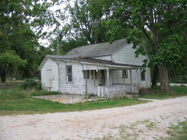
| House, 2005 Ph10985-004.jpg |
House, NW Corner, 2005 Ph10985-002.jpg |
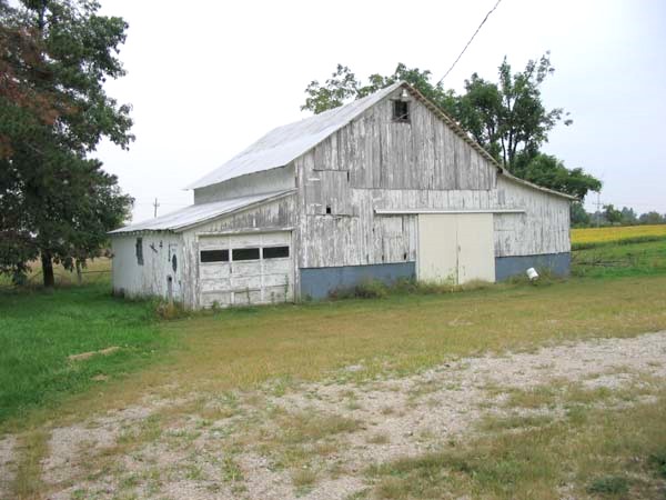
Barn, 2005 Ph10985-001.jpg |
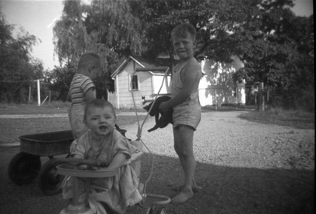
Phil, Janet, Walt, Jr Summer 1950 Back of House Ph12504-009.jpg |
Farm House 2021 |